
Logan and Albert Conservation Association

How much is a koala worth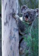 ? How many exist in their natural bushland areas?
Can you imagine a world without koalas?
Where would Australia be without them and the $2.5 billion a year in tourism they help bring in?
This is the value given by CEO Deborah Tabart of Australian Koala Foundation in a recent article about the unique mapping tool available on the AKF website. Although it's free to access, the information cost $8 million and thousands of volunteer hours to develop. Everyone in the world can now look at over 2000 koala habitat sites where 100,000 trees have been individually measured. Landowners can mark their own koala sightings and developers can see where koalas live. Check out the mapping tool here.
Not all landowners are happy to share their land with koalas - developing for housing or industry.In 1923 it was thought that, from an original population of over 10 million, there were as few as 45,000 koalas left in Australia. Now with 80 per cent of koala habitat cleared for buildings, roads, hard infrastrucure and resource exploration that number is far lower. For a koala, 'no tree' means 'no me'. Read the article here.
Unfortunately the property industry feels no obligation to help protect this unique Australian marsupial - claiming that houses would cost more - obviously passing on all costs to the consumer. Their concerns are reported in this Financial Times article.
The current Senate Inquiry into the status, health and sustainability of Australia's koala population with an interim report tabled 13 May 2011, advising that the committee now intends to table its final report on Wednesday, 24 August 2011.
The submissions received can be read here.
The conservation movement - and LACA Logan and Albert Conservation Association especially - believe the long term survival ie health and sustainability of the koala in Queensland will only be achieved with its being listed as endangered under Australia's EPBC Act.
If you share our concerns, consider writing to your representative as well as Minister Tony Burke who is tasked with the responsibility of making a ruling on the future status of the koala. Current management plans and policies do not protect the koala's habitat and food source. Science is still learning about the ecology and behaviours of the koala but I think there is little doubt that if we clear trees for housing then the koala's survival is limited.
Legislation that has planning power, plus tax or financial incentives to encourage and support private landholders to protect biodiversity are part of the necessary foundation stones, if Australia is going to save the koala on private land. NO TREE NO ME - sums up what we need to do.
ASK FOR the immediate removal of the proposed industry and business area proposed for the North Maclean identified growth area.
WHY?
Community in the surrounding rural residential areas has continued to oppose the proposed industrial and business land use concept for this site since 2005 and has made submissions at all local government ( Beaudesert Shire Council , Logan City Council) and state government ( OUM, DIP) planning processes since 2005.
North Maclean was an identified growth area in the SEQRP 2009 - 2031 . North Maclean has not been adequately assessed for its biodiversity and natural resource values which are environmental assets of South-east Queensland and Logan City Council. The proposed site for industry and business at North Maclean is a biodiversity hotspot. Any activity which occurs within that area should be considered for its natural capital - not just land within a geographical area with no other land use values.
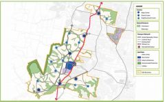 Greater Flagstone - what is your vision?
An area criss-crossed by roads - all needing to be upgraded and with extra lanes?
An area where increased human settlement of affordable housing - constructed before adequate wildlife and biodiversity studies are completed by impartial consultants?
An area already being cleared without adequate erosion and sediment controls in place
An area not contained within one connected geographical space
An area where the concept of identified growth areas is include within the UDA Urban Development Area [ renamed in last SEQRP from INVESTIGATION AREAS to identified growth areas - a misleading use of language and terminolgy for those new to the area and SEQRP documents]
OR DO YOU WANT AN AREA WHICH DEMONSTRATES THE ON GROUND PRINCIPLES OF
ECOLOGICAL SUSTAINABLE DEVELOPMENT?
Read LACA president's presentation notes from Greenbank submission writing workshop Tuesday 19 April 2011.
 Greater_Flagstone_submission_Workshop_19_04_11.pdf Bytes 01/01/1970, 10:00
View presentation  greater_flagstone_april_2011_edo_workshop.pdf
Although many of us want to have better roads all the road changes will mean more tree clearing - meaning loss of habitat and other services provided by trees.
Have you seen Mt Lindesay Highway recently [ at least 3 koalas were seen in area by the wildlife spotters] ? This is an example of what is to come .
Following roads are listed in ULDA documents •Teviot Rd (Middle Rd - Kilmoylar Rd •Homestead Dr ( to Teviot Rd) •Cusack lane ( Teviot Rd - Johanna St) •Johanna ( Cusack Lane - Mt Lindesay Hway •Camp Cable Rd ( Mt Lindesay - Waterford-Tamborine Rd) •Crowson Lane ( Greenbank - Mt Lindesay Highway) •Greenbank Rd ( Crowson Lane – Mt Lindesay Hway) •Stoney Camp Rd ( Teviot Rd – Mt Lindesay Highway) •Mt Lindesay Highway (Johanna St to Logan Motorway) •Chambers flat Rd ( Chambers Flat to Waterford-Tamborine Rd) •Goodna Rd – Springfield Greeenbank Arterial – Middle Rd.
If you click on image above, a new page will open for the ULDA Urban Land Development Authority Greater Flagstone UDA Proposed Development Scheme documents.
There are many background reports [30 as of today 26 April]. This page has links to 33 guidelines,posters or strategies today.
COME ALONG TO THE JIMBOOMBA SUBMISSION WRITING WORKSHOP WITH EDO AND LACA
Wednesday 27 April at Caddies 7-9 pm
33 South St Jimboomba
HARDCOPIES OF ALL DOCUMENTS SHOULD BE AVAILABLE AT JIMBOOMBA GREENBANK and LOGAN VILLAGE LIBRARIES for reading on site
 The Developer has WITHDRAWN their Development Application number DEV2010/095.
 Spread the word for everyone to attend the next meeting.
THIS WEDNESDAY 6th April 2011, 7PM, Greenbank Community Centre.
Please tell everyone you know about the meeting.
There is IMPORTANT info to share with you. The Developent Scheme for Greater Flagstone was released Friday 1 April 2011.
GREENBANK is STILL declared. We have 30 business days (from the 1st April) to put in a submission against the inclusion of Greenbank in the Urban Development Area.
Submissions must be received by 20 May 2011
LACA is organising Environmental Defenders Office workshops to be held in the local area on the 19 April and the 27 April to assist the community with writing their submissions.
Attend the meeting on Wednesday 6th April 2011 to hear what we need to do.
See you there, tell your neighbours, family and friends
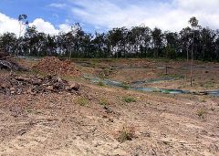 Residents near bushland being bulldozed to make way for a planned satellite city are mounting a fierce and growing battle against the sweeping powers of the Queensland government's Urban Land Development Authority. Greater Flagstone, west of Jimboomba, was chosen during the state government's Growth Summit last year as the site for a new satellite city to absorb 130,000 new southeast Queensland residents in 21 years.
But some of the existing 4000-strong population fear cheap houses will be built en masse without thought for necessary infrastructure or their rural lifestyle.
Resident Mike Kelly, founder of the Save Greenbank campaign, said concerns had fallen on deaf ears in the state government, while the mass clearing of land continued without their consultation.
"The ULDA is bastardising the existing culture and lifestyle here for fast-tracking purposes, which are completely inconsistent with the real needs of the community," he said. Mr Kelly said residents on acre blocks would soon have up to seven neighbours along their fence lines. "There are no guarantees for the development of infrastructure ... even the repair of existing roads," he said. "There are no guarantees that new houses will be made affordable for first-home buyers, rather than investors. We are being kept in the dark here."
Planning Minister Stirling Hinchliffe holds the future of our rural and acreage lifestyle living in his hands. Councils are required to follow a process to allow for community consultation - not so with the statuatory powers given to ULDA. See source and rest of story with comments here.
Go to campaign website to see how local residents are working to restore our democratic rights to be consulted on these issues.
SEND IN YOUR OWN SUBMISSION. Get some tips here. Contact you local state and federal members and HAVE YOUR SAY.
The Logan and Albert Conservation Association (LACA) completely opposes the proposed new 110 KV Energex sub transmission line from Loganlea to Jimboomba. We believe the proposed network upgrade from Loganlea to Jimboomba does not balance social, environmental and economic considerations as claimed in the Final IAR. LACA shares the concerns of the wider community about the negative impacts on the community as well as the negative impacts on the natural environment and wildlife. Koalas have been historically recorded in this region and continue to survive here. The Final IAR confirms that this proposal will result in a loss of habitat, habitat connectivity and biodiversity, especially in the southern section of this proposed network upgrade along Camp Cable Rd and Waterford Tamborine Rd. Energex is intending to fragment habitat connectivity within 3 bioregional corridors
Read our submissions here.
 Energex_Loganlea_to_Jimboomba_July_2010_LACA.pdf
and
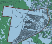 New koala planning provisions will be introduced in December 2009 and comprise:
 New koala conservation state planning regulatory provisions: the Proposed South East Queensland Koala Conservation State Planning Regulatory Provision ( 746 KB 38p) and proposed koala habitat mapping that will regulate new development in koala habitat areas. You can access the several area maps from this dip page http://www.dip.qld.gov.au/maps/seq-koala-habit-regulatory-maps.html
Map 24 http://www.dip.qld.gov.au/resources/map/koala-regs/koala-sprp-maps-24.pdf does not show any koala habitat in the Flagstone area? Difficult to believe - if you see all the surrounding habitat? http://www.dip.qld.gov.au/resources/map/koala-regs/proposed-seq-koala-conservation-seqkc-map-24.pdf
Or you can search the archives here